Hi, All -
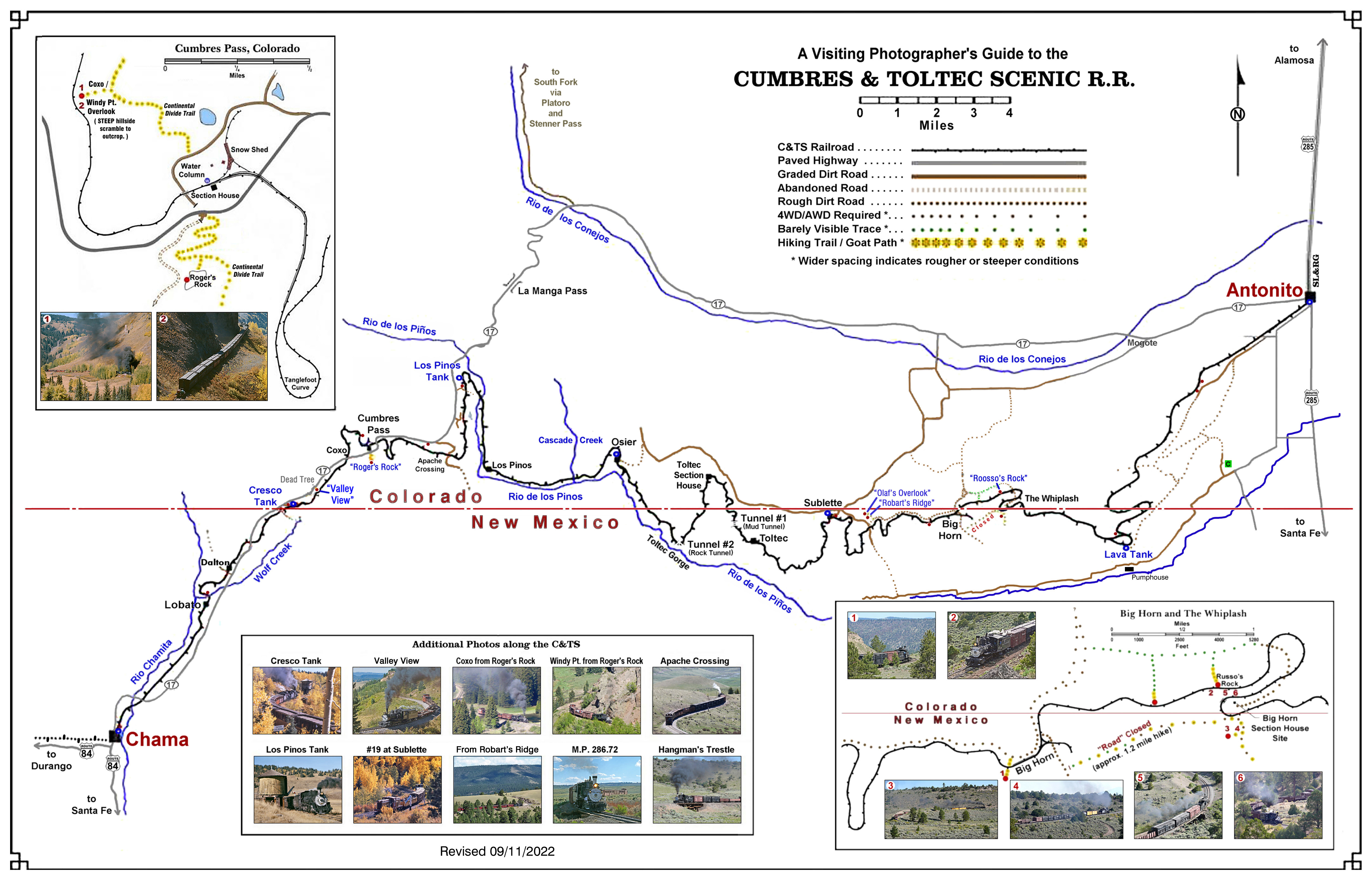
With Fall Colors fast approaching and a commemoration of the Toltec Rattler just over six weeks away, I've been motivated to expand on a project that was started several years ago — a simplified map of the C&TS showing the roads, ruts and goat-paths that I have followed to get a few of my photos.
IIRC, Roger Hogan sent me to "Roger's Rock" on June 16th
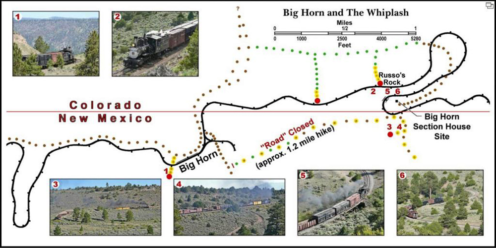
*, and I returned to a couple of my old haunts near Apache Crossing and M.P. 286.72 south of Antonito, but it was on the 21st that the exploring done on the previous two days really paid off. Here's the map - with enlarged sections showing the trails near Cumbres and the traces both above and below The Whiplash - that should make the directions given in last year's post - [
ngdiscussion.net] - a little clearer
:

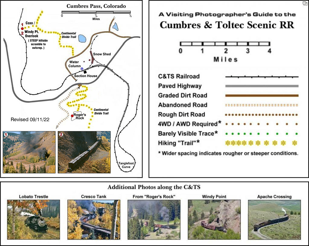
The locations of roads are approximate - I don't own a GPS device, but have driven or hiked the ruts and trails shown and have trusted my memory to some extent. The relationships of the roads shown above and in the enlarged "corners" below will hopefully prove close enough to allow you to find the locations where all the attached photos were taken. (The above map has been revised as of 09/11/22 to allow downloading and printing — it's 11"x17" at 300 dpi and includes all of the following components on one page.) The "corners" may be unreadable when displayed on a monitor so they're reproduced below for clarity.
See [
ngdiscussion.net] for further information and enlarged versions of photos #5 and #6, above. For larger versions of photos #2, #3 & #4 - and others taken
from "Russo's Rock" - see [
ngdiscussion.net] and [
ngdiscussion.net].
Here's a rough guide to finding the overlook of the north side of Windy Point
:
 . . .
. . . and here's the trail to "Roger's Rock".
* The hike and scramble to the "overlook" on the north side of Windy Point is NOT easy, and means sacrificing a couple of hours for a very different view of the railroad. The "legend" is also re-printed here in a more legible size
:

-
Roosso
* See [
ngdiscussion.net] for some views taken
from "Roger's Rock".
p.s. Here's a reprint of the (corrected) instructions for finding "Russo's Rock" that were posted on June 28, 2008, on the thread beginning with [
ngdiscussion.net]
:
"Happy to share directions - just as Roger has shared with me - and presuming you know how to find Sublette. (Also provided I have first dibs on "Russo's Rock" the next time #315 makes an afternoon or evening run from Antonito to Osier . . .  )
)
1) On the road to Osier, take the road toward the curves near mp 305 and 303 (the last road to the left before the left turn to Sublette).
2) After passing the curve near mp 305 (where the gravel pile is currently located), continue over the hill and about halfway down the other side; take the rough road up to the left, toward Bighorn. IIRC, there is a small Forest Service sign for "Road 75". It's only steep for the first hundred or two hundred yards, but it's pretty rough in spots later on. No problem for my AWD Ford Escape, but I wouldn't recommend trying it in a 2WD sedan ... (If you come to the grade crossing near mp 303, you have missed the left turn.)
3) Continue past Bighorn on "Road 75" about ¼ to ½ mile, past the cattle guard at the state line. Eventually you will see a pair of ruts off to the right.
4) Follow the ruts until you see a grassy strip going off to the right which seems to be relatively free of sagebrush and rocks (at least compared to the surrounding hillside).
5) After about ½ mile, there is an even fainter grassy strip off to the right which leads to a place where you can see the Whiplash trestle below and off to the northeast.
6) Continue on the original grassy strip about ½ mile until you see a small signpost off to the right, near a thick but not too tall ponderosa pine. I was able to follow a very faint grassy swath a little way past the sign, but had to stop near the tree due to some rocks. If I still had my 4-Runner I would have gone around them and continued on, but the Escape doesn't have as much ground clearance.
7) From the pine near the sign, walk southeast about 0.1 to 0.2 mile toward a round juniper tree. From this juniper you should be able to see down the hillside to "Russo's Rock". This overlooks all three levels of the Whiplash, with good views of the top level to both the east and the west.
In lieu of #3-#7 above, park near the east switch at Bighorn and walk eastward along the roadbed about 1½ miles. "Russo's Rock" is above the track about ½ mile east of mp 298, but there are several similar spots along the upper track of the Whiplash.
GOOD LUCK! 
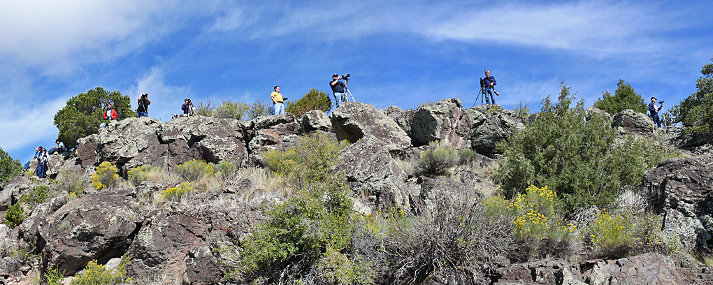
Apparently the directions given above aren't too far off — here's the crowd at "my" rock on the morning of 09/09/13
:

I was riding in the open gon of the "chase" train running ahead of #315 when I took the above and had a chance to apprehend the trespassers when we disembarked on the upper level of
The Whiplash, but I decided to focus on the run-by instead. See [
ngdiscussion.net] for a photo.
pps. To minimize the confusion caused by the use of the abbreviation 'RR' to identify so many different entities, consideration is being given to either renaming "Roger's Rock" to "Hogan's Hump"
-or- renaming "Russo's Rock" to "Piedra de los Locos Viejos y Verdes Perdidas en Purgatorio"
. . . 
Edited 25 time(s). Last edit at 09/25/2022 01:27PM by Russo Loco.
 )
)


